COLUMN: Tales from the Gravel Ridge – The unique geography of Rosengard
Advertisement
Hey there, time traveller!
This article was published 09/05/2024 (739 days ago), so information in it may no longer be current.
Geography is the study of the lands of the earth, including its various features as well as its inhabitants.
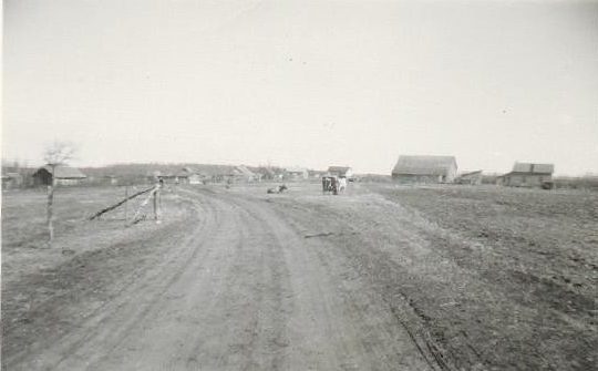
The geography of Rosengard, the community that was home to me for the first two decades of my life, was, in my opinion, truly unique. Every community doubtless has its own distinctive features. However, long before recorded history had expounded on the uniqueness of Rosengard’s geography, glacial Lake Agassiz, that immense body of water that covered so much of Saskatchewan, Manitoba and Ontario, as well as parts of the northern United States, was slowly but surely melting. In its wake beach ridges developed, and bit by bit, Rosengard’s all-weather roadway came into being.
The staff at the Winnipeg Land Titles Office was most accommodating when I indicated to them a while back that I wished to search the title for a somewhat complicated legal description. Back then a certain relaxed atmosphere prevailed at the Land Titles Office. Perhaps it is so to this day. However, I am quite certain that the very large, heavy binders that held the titles containing the legal descriptions of land located within the jurisdiction of that office, are no longer readily available to those wishing to do a legal search of a certain parcel of land.
The legal description that was of particular interest to me on the occasion of my visit to the Land Titles Office was one I had copied from the agreement entered into on September 28, 1938 between Julius Block, who owned the property in question, and my father, Cornelius H. Falk who was in the process of purchasing it. The description was indeed complex, but the Land Titles staff, being familiar with such terminology, had no difficulty making the necessary calculations and sketches. They informed me that a plan had been registered for the property, and that I could visit the Surveys section to take a look at it. I immediately did that, and then purchased a copy of the plan. I had no need or purpose for this acquisition, but it held particular meaning for me. It was the place where I was born, and that was home for us for many years.
What intrigues me particularly about the simple line sketches on my copy of the plan is the prominent place the gravel ridge holds. It seems to be the determining factor for the manner in which the land in the community had been allocated. While I knew that the ridge didn’t follow a government road allowance along a section line the way roads in rural Manitoba generally do, the angle at which it cuts across Section 12 seems particularly pronounced when seen on a plan. Somehow it didn’t seem that way when I used to walk the one mile length of it that ran past our place, and those of our neighbours, and also, the Rosengard School.
If the ridge had not been where it is, there would not have been a road at that location, and presumably some of the Rosengard properties would have had different boundaries from the ones they then had. The place that was home to me for the first 21 years of my life might well have been in another location, but for the ridge. The 20 acres my parents owned consisted of a long, narrow strip of land, with access to a public road approximately half a mile from where our farmyard was located. That presumably would have been the place where the buildings would have been constructed, if the ridge had not existed. We would have had a driveway facing west instead of south.
The families living on the farms along the one-mile stretch of gravel ridge were our neighbours, and gave us a very real sense of community. If our driveway had been located half a mile to the west, on the conventional grid road allowance, all that would have been different. The geography of the diagonal gravel ridge continues to inform my memories of Rosengard.