Piney and Stuartburn to address flooding
Advertisement
Hey there, time traveller!
This article was published 18/08/2024 (707 days ago), so information in it may no longer be current.
Annual flooding is hurting Piney and Stuartburn, forcing road closures, loss of jobs, and safety concerns according to municipal officials.
The municipalities, along with the Seine Rat Roseau Watershed District are looking into making a dike and retention area that would help ease the flooding going south.
The main affected areas, which used to be farmland, have turned into lakes. The excess water fills ditches, farmland, and most years, roads.
In the last five years, Piney and Stuartburn have had to close stretches of gravel roads during the winter because water levels are too high, making the roads unusable. These are roads that have been used for years, with school buses now taking large detours to pick up children for school, an extra four miles for some routes.
Horseshoe Lake, also known as Sundown Lake, is a manmade lake built by Ducks Unlimited Canada (DUC), which sits northeast of Sundown. After it was made in 1956, the province put in a drain so the lake could maintain its level, and so DUC would have a better space for aquatic life.
But that came with issues, with more water being drained than expected. Water comes spewing out where the drain ends, on the border of Stuartburn and Piney, along Municipal Road 54E, which is one of the roads that closes during the winter.
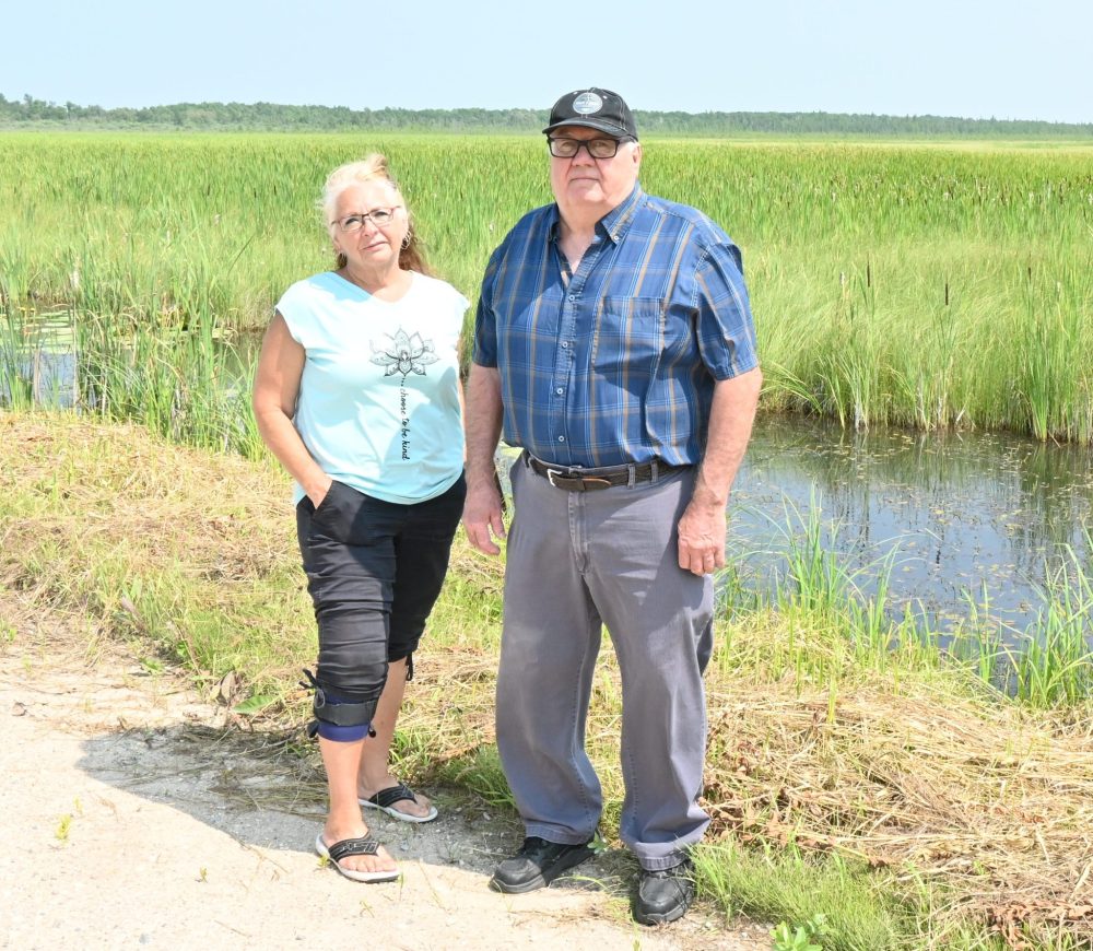
The reeves of both municipalities say this is a problem, as the amount of water has turned what used to be farmable grounds into a bog. Piney Reeve Wayne Anderson said hay farmers had used the land for generations, until the water became unmanageable, as the province didn’t take ownership of what happened to the excess water once it was past the drain, a couple hundred feet south of Provincial Road 201.
“There’s a young farmer out here, that hasn’t been able to farm for six or seven years, and he’s one very angry young man. He’s third generation, and he can’t farm the land,” said Stuartburn Reeve Michelle Gawronsky.
She added that in wet summers, the water can stay on the road all season long. This year, patches of the road were soft, with the ground sinking under people’s feet because the water was so close.
“Mother Nature has been taking over more and more and more of this area, where it’s going to be less productive for the folks around here.”
Gawronsky has been working with neighbouring RMs and U.S. counties to control the flooding happening in the Roseau area. Gawronsky, along with representatives from Piney, Emerson-Franklin and three U.S. counties run the Roseau River International Watershed Committee, which has been dealing with water control since the 1997 flood.
Anderson said that since the ‘97 flood, officials in Manitoba have been keeping water levels at close to max height instead of lowering it.
“If you hold water back and everything’s full, and you get a big rain or a big snowmelt, then it all flows over anyway,” said Anderson. “The trick about water retention is to store the water while getting a big rain or a big snowfall, you gradually let it go while the sun is shining back down to zero levels, then you got full storage levels again. They just want to keep it full all the time, that doesn’t do anything.”
In Minnesota, they have been lowering water levels, which has had a positive impact on their land. Gawronsky said that the U.S. side is even rebuilding Roseau Lake, which was drained by farmers in the early 1900s, by rerouting the Roseau River, similar to how it used to naturally flow.
The current U.S. side of the Roseau River was diverted from its original path to help farmers, but it came with unexpected consequences, with water coming back over the Canadian border, pooling at the Arbakka dam.
“They’ve started to realize now that that should never have been done, it should have just stayed in its natural flow,” Gawronsky said.
She said Stuartburn residents aren’t happy about how the land has changed, with people moving, quitting farming altogether, and getting jobs outside the RM instead.

“It breaks my heart for them, I totally empathize, I sympathize with the ratepayers, and that’s just where I’m not going to give up, I’m just going to keep talking and fighting for folks,” she said.
Stuartburn has committed to upkeeping part of the dike, providing a piece of property for the dike to be placed, and $50,000 for the construction.
“We want to make sure we’re solving this for once and for all, that we’re not putting another Band-Aid on it, we need to solve this issue. I want my granddaughters who live in this area to not worry about flooding.”
Piney hasn’t promised any help to the project yet. Anderson said he doesn’t want to promise anything while so many questions are left to be answered by the Seine Rat Roseau Watershed District and the province.
The RMs of Emerson-Franklin and Montcalm have also committed monetary aid for the project, as the water does have a small impact on their municipalities.
The flooding has also been a problem for non-farmers. Gawronsky said she’s scared for the children in the area, who only need to take one wrong step before being submerged.
In 2022, a Stuartburn man drowned after hitting the ditch while driving.
According to a presentation given at an RM of Hanover council meeting in July, the proposed fixes range from a cost of $228,000 to $1.93 million, with the lowest of the three options covering only 18 hectares, and the biggest 408.
Gawronsky said that the lowest option isn’t feasible, as won’t provide a long-term fix.
Ward 4 Hanover Coun. Ed Penner, who used to be a councillor for Stuartburn said the most appropriate option to him, would be between the most expensive, and middle options. The middle option would cost $437,000 and cover 141 hectares.
– with files from Greg Vandermeulen